In 2022, the New Mexico Supreme Court ruled that the state constitution guarantees public access to rivers and streams passing through private land. The court stated that while anglers and other members of the public seeking to enjoy New Mexico's waters cannot cross private land to access those waters, they could walk, wade, or float in the streambed for recreational purposes. "These waters belong to the people of this state and we stand ready to use every available tool to ensure public access to these natural resources," Attorney General Raúl Torrez said at the time.
This ruling is particularly relevant for rivers like the Canadian where the majority of land bordering the river is privately owned. There are sections managed by New Mexico's State Land Office, the Forest Service and the Bureau of Land Management, but the vast majority remain in private hands.
The Canadian is a major Western waterway that flows from Colorado nearly to Arkansas. In New Mexico, sections of the Canadian are navigable between Raton and Conchas Reservoir during years of high spring snowmelt or increased springtime precipitation. Most years, this section does not have sufficient flow for boating. When it flows, though, it is one of the most stunning whitewater trips in the state.

The Canadian becomes particularly interesting downstream of Taylor Springs, with Class II, Class III, and even Class IV boulder garden rapids. Depending on water levels, portages can be required, and large rafts are not recommended. This is kayak and canoe water. Blind drops are quite common and should be scouted. First aid and swift water rescue training are musts for boaters on this part of the Canadian.
Flash floods are common on this stretch as rainstorms far upstream and out of view can contribute tremendous amounts of water to the river. Due to these unexpected flows, be sure to set camp well above the riverbank. Just as problematic can be a sudden drop in flows that can leave paddlers portaging sections.
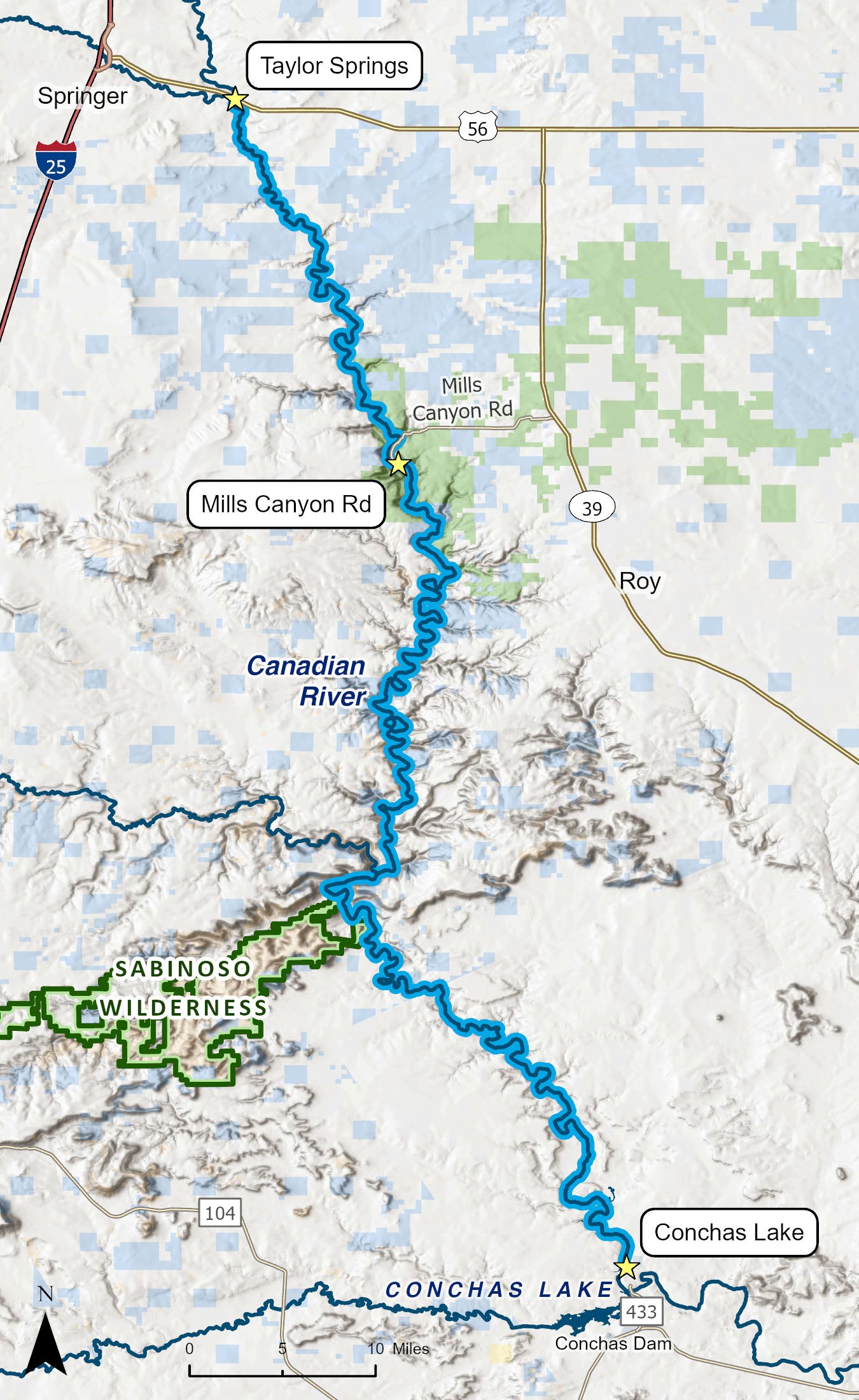
Access for this 123-mile route is located just east of Springer, above the confluence with the Cimarron River and near the ghost town of Taylor Springs, first settled in the 1880s. The farming community grew large enough to have its own post office from 1905 to 1909 before declining and later disappearing during the Great Depression. Just to the south sit the El Vado de las Piedras and Colfax County segments of the Santa Fe Trail. River access near Taylor Springs is located on private property. Plan ahead and obtain permission to access private property before you launch or seek an alternate put-in.
From Taylor Springs to the bridge on Mills Canyon Road is about 31 river miles. From Mills Canyon Road to Conchas Lake State Park is 91 miles. Shuttle distances are very long, so adventurers would be smart to plan an extra day or even two in their itineraries.
Once you begin this run, there is no access until rugged Mills Canyon, and the route requires advanced paddling skills, particularly for canoeists. People injured along this route will have no way to obtain rapid assistance. The remoteness of this run is both the biggest pleasure and the biggest hazard of this section. The only available campgrounds are in Mills Canyon, but plenty of natural campsites line the length of the river. This four- to six-day trip is a truly wild adventure.
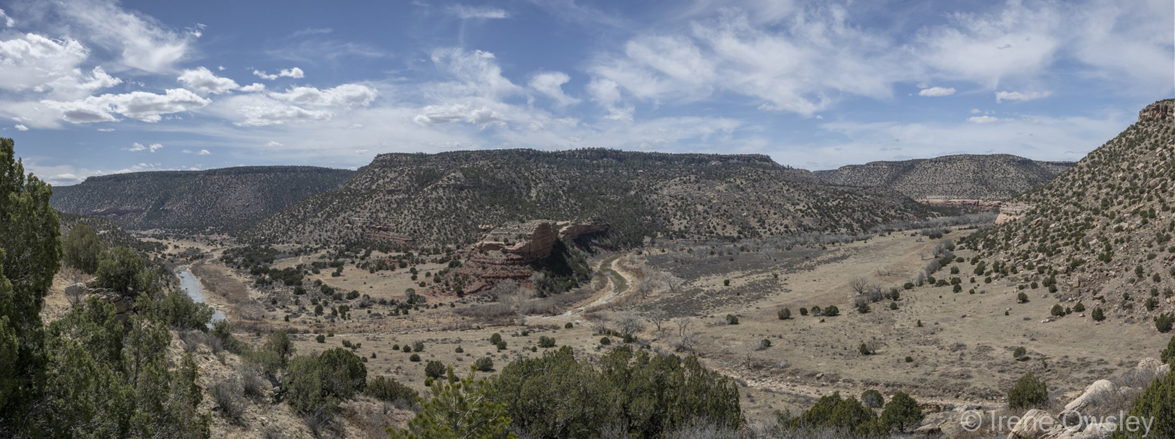
The river flows through granite cliffs and deep canyons of sandstone populated with golden and bald eagles, hawks, owls, and other raptors. The river is extremely remote, rich in wilderness quality lands, healthy wildlife populations, archaeological sites, and opportunities for adventure and solitude. The uplands are largely semi-arid grasslands populated with pronghorn and deer.
Mills Canyon appears out of nowhere. Here, the Canadian cuts through forested Cretaceous cliffs and down through Jurassic and Triassic sandstone to a lush river bottom teeming with wildlife. Mills Canyon owes its abundance to elevation change. On the rim of the canyon, the ecosystem is montane forest. The canyon bottom is a purely desert environment, ribboned by the jungle-like riparian forest lining the muddy river. This landscape diversity creates the perfect conditions for a multitude of ecosystems. Five hundred or more species of plants and animals have been documented in the canyon, not to mention the mind-blowing diversity of birds. Spring migration makes Mills a treasure. Vireos, tanagers, grosbeaks, wrens, orioles, woodpeckers, sparrows, swifts, swallows, owls, and the yellow-breasted chat are all commonly seen species.
In 1881, Melvin Mills, a New Mexico lawyer, planted some 14,000 fruit and nut trees along the river bottom in Mills Canyon. Until 1912, thousands of tons of peaches, pears, plums, cherries, apricots, and almonds were hauled from the canyon by wagon to market in the surrounding communities. At one point, a small resort popped up. Today, Mills' abandoned offices and the old stagecoach station are home to violet-green swallows, white-throated swifts, and Western screech owls. Mills Canyon has been viewed as ideal for wilderness designation at some point in the near future.